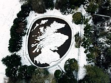
The Great Polish Map of Scotland is a large (50 m x 40 m) three-dimensional, outdoor concrete scale model of Scotland, located in the grounds of the Barony Castle Hotel, outside the village of Eddleston near Peebles in the Scottish Borders.[1] It is also known as the Mapa Scotland (derived from Polish mapa Szkocji) or the Barony Map. The brainchild of Polish war veteran Jan Tomasik, it was built between 1974 and 1979 and is claimed to be the world's largest terrain relief model.[1] The sculpture is a category B listed building,[2] and has been restored by the Mapa Scotland volunteer group.[3]
- ^ a b Bruce Gittings; Royal Scottish Geographical Society. "Polish Map of Scotland". Gazetteer for Scotland. The Editors of The Gazetteer for Scotland. Retrieved 11 July 2012.
- ^ Historic Environment Scotland. "Barony Castle Hotel, The Great Polish Map of Scotland (Category B Listed Building) (LB51957)". Retrieved 26 March 2019.
- ^ Mapa Scotland. "Mapa Scotland website". Retrieved 24 January 2014.