Greene County | |
|---|---|
 Courthouse, built 1838, in Stanardsville | |
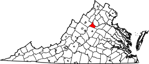
 Location within the U.S. state of Virginia | |
 Virginia's location within the U.S. | |
| Coordinates: 38°18′N 78°28′W / 38.3°N 78.47°W | |
| Country | |
| State | |
| Founded | 1838 |
| Named for | Nathanael Greene |
| Seat | Stanardsville |
| Largest community | Twin Lakes |
| Area | |
| • Total | 157 sq mi (410 km2) |
| • Land | 156 sq mi (400 km2) |
| • Water | 0.7 sq mi (2 km2) 0.4% |
| Population (2020) | |
| • Total | 20,552 |
| • Density | 130/sq mi (51/km2) |
| Time zone | UTC−5 (Eastern) |
| • Summer (DST) | UTC−4 (EDT) |
| Congressional district | 7th |
| Website | www |
Greene County is a county in Virginia in the eastern United States. As of the 2020 census, the population was 20,552.[1] Its county seat is Stanardsville.[2]
Greene County is part of the Charlottesville, VA Metropolitan Statistical Area.
In recent years, Greene County has become a tourist destination for metropolitan areas to escape to the Shenandoah National Park and Virginia's scenic foothills.
- ^ "Greene County, Virginia". United States Census Bureau. Retrieved January 30, 2022.
- ^ "Find a County". National Association of Counties. Archived from the original on May 31, 2011. Retrieved June 7, 2011.
