| Greenethorpe New South Wales | |
|---|---|
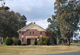
 War memorial hall | |
| Coordinates | 33°59′47″S 148°24′09″E / 33.99639°S 148.40250°E |
| Population | 320 (2011 census)[1] |
| Established | 1908 |
| Postcode(s) | 2809 |
| Location | |
| LGA(s) | Weddin Shire |
| State electorate(s) | Cootamundra |
| Federal division(s) | Hume |
Greenethorpe is a town in the Central West region of New South Wales, Australia. The town is located in the Weddin Shire local government area, 345 kilometres (214 mi) west of the state capital, Sydney. At the 2011 census, Greenethorpe and the surrounding area had a population of 320.[1]
The village, with the associated "Mount Oriel" homestead (known locally as Iandra Castle), is a rare example in Australia of the manorial system, "the likes of which may not exist elsewhere in the state or nation".[2]
- ^ a b Australian Bureau of Statistics (31 October 2012). "Greenethorpe (State Suburb)". 2011 Census QuickStats. Retrieved 2 April 2015.
- ^ "Iandra Homestead Pastoral Estate". New South Wales State Heritage Register. Department of Planning & Environment. H01723. Retrieved 18 May 2018.
 Text is licensed by State of New South Wales (Department of Planning and Environment) under CC BY 4.0 licence.
