Greenfield, Indiana | |
|---|---|
 Hancock County Courthouse in downtown Greenfield | |
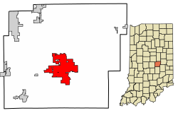
 Location of Greenfield in Hancock County, Indiana. | |
| Coordinates: 39°47′41″N 85°45′25″W / 39.79472°N 85.75694°W | |
| Country | United States |
| State | Indiana |
| County | Hancock |
| Government | |
| • Type | Mayor–council government |
| • Mayor | Guy Titus (R) |
| Area | |
| • Total | 13.71 sq mi (35.50 km2) |
| • Land | 13.56 sq mi (35.12 km2) |
| • Water | 0.15 sq mi (0.38 km2) |
| Elevation | 889 ft (271 m) |
| Population | |
| • Total | 23,488 |
| • Density | 1,713.20/sq mi (661.47/km2) |
| Time zone | UTC-5 (EST) |
| • Summer (DST) | UTC-4 (EDT) |
| ZIP code | 46140 |
| Area code | 317 |
| FIPS code | 18-29520[6] |
| GNIS feature ID | 2394986[4] |
| Website | www |
Greenfield is a city in and the county seat of Hancock County, Indiana, United States[8] It lies in Center Township and is part of the Indianapolis metropolitan area. The population was 23,488 at the 2020 census.[9]
Greenfield was a stop along the Pittsburgh, Cincinnati, Chicago and St. Louis Railroad that connected Pittsburgh to Chicago and St. Louis.
- ^ "Mayor Guy Titus". City of Greenfield Indiana. Retrieved April 18, 2024.
- ^ Swift, Shelley (October 24, 2023). "Happy Guy: Longtime city employee seeks to become Greenfield's next mayor". Greenfield Reporter.
- ^ "2019 U.S. Gazetteer Files". United States Census Bureau. Retrieved July 16, 2020.
- ^ a b U.S. Geological Survey Geographic Names Information System: Greenfield, Indiana
- ^ Cite error: The named reference
wwwcensusgovwas invoked but never defined (see the help page). - ^ "U.S. Census website". United States Census Bureau. Retrieved January 31, 2008.
- ^ "Population and Housing Unit Estimates". United States Census Bureau. May 24, 2020. Retrieved May 27, 2020.
- ^ "Find a County". National Association of Counties. Archived from the original on May 9, 2015. Retrieved June 7, 2011.
- ^ "Quick Facts: Greenfield city, Indiana". American Factfinder. U.S. Census Bureau. Retrieved January 29, 2023.

