Town of Grenfell | |
|---|---|
Town | |
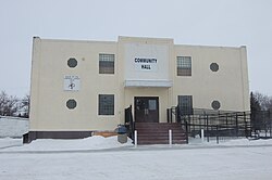
 Community Hall | |
| Coordinates: 50°25′00″N 102°56′00″W / 50.416667°N 102.933333°W | |
| Country | Canada |
| Province | Saskatchewan |
| Rural Municipality | RM of Elcapo # 154 |
| Post office Founded | 1883 |
| Incorporated (village) | 1894 |
| Incorporated (town) | 1911 |
| Government | |
| • Mayor | Rod Wolfe |
| Area | |
| • Total | 3.17 km2 (1.22 sq mi) |
| Population (2016[1]) | |
| • Total | 1,099 |
| • Density | 347.0/km2 (899/sq mi) |
| Time zone | CST |
| Postal code | S0G 2B0 |
| Area code | 306 |
| Highways | Trans-Canada Highway 1, Highway 47 |
| Website | townofgrenfell |
| [2][3][4] [5][6] | |
Grenfell (Canada 2016 Census population 1,099)[1] is a town in Southern Saskatchewan, Canada. It is situated at the junction of Highway 47 and the Trans-Canada Highway 1 130 kilometres (80 mi) east of Regina, the provincial capital. It is 24 kilometres (15 mi) south of the Qu'Appelle Valley where Crooked Lake Provincial Park (at Crooked Lake) and Bird's Point Resort (at Round Lake) are popular beach destinations and are accessed by Highway 47.[7]
European settlement from Ontario and the British Isles began in 1882 before the Canadian Pacific Railway reached the site of the town,[8] and "the town's name honours Pasco du Pre Grenfell, a railway company official."[9] The post office was established in 1883.
- ^ a b "Census Profile". 2016 Census. Statistics Canada. February 8, 2017.
- ^ McLennan, David (2006). "Grenfell". Encyclopaedia of Saskatchewan. Canadian Plains Research Centre. Archived from the original on July 5, 2017. Retrieved May 18, 2009.
- ^ National Archives, Archivia Net. "Post Offices and Postmasters". Archived from the original on October 8, 2012. Retrieved May 8, 2009.
- ^ Government of Saskatchewan, MRD Home. "Municipal Directory System". Archived from the original on November 21, 2008. Retrieved May 8, 2009.
- ^ "Hon. Steven Bonk". Legislative Assembly of Saskatchewan. Government of Saskatchewan. Archived from the original on May 27, 2018. Retrieved January 10, 2018.
- ^ Commissioner of Canada Elections, Chief Electoral Officer of Canada (2005). "Elections Canada On-line". Archived from the original on January 15, 2013. Retrieved May 8, 2009.
- ^ Adamson, Julia (1925). "Saskatchewan, Canada, Rand McNally 1924 Indexed Pocket Map Tourists' and Shippers' Guide" (Published online November 11, 2003). Online Historical Map Digitization Project. Waghorn. Retrieved May 15, 2009.
- ^ David McLennan, "Grenfell", The Encyclopedia of Saskatchewan http://esask.uregina.ca/entry/grenfell.html Archived July 5, 2017, at the Wayback Machine (retrieved March 23, 2014)
- ^ David McLennon, "Grenfell", Encyclopedia of Saskatchewan. Archived July 5, 2017, at the Wayback Machine Retrieved November 19, 2007.

