| Guaduas Formation | |
|---|---|
| Stratigraphic range: Maastrichtian-Paleocene ~ | |
 Coal from the Guaduas Formation, Páramo de Ocetá | |
| Type | Geological formation |
| Underlies | Cacho Formation |
| Overlies | Guadalupe Gp. Arenisca Labor-Tierna Fm. |
| Thickness | up to 1,090 metres (3,580 ft) |
| Lithology | |
| Primary | Shale |
| Other | Sandstone, coal |
| Location | |
| Coordinates | 5°05′N 74°36′W / 5.083°N 74.600°W |
| Region | Middle Magdalena Basin Magdalena River Valley Altiplano Cundiboyacense Eastern Ranges, Andes |
| Country | |
| Type section | |
| Named for | Guaduas |
| Named by | Hubach |
| Location | Guaduas |
| Year defined | 1931 |
| Coordinates | 5°05′N 74°36′W / 5.083°N 74.600°W |
| Approximate paleocoordinates | 0°36′N 52°30′W / 0.6°N 52.5°W |
| Region | Cundinamarca, Boyacá |
| Country | |
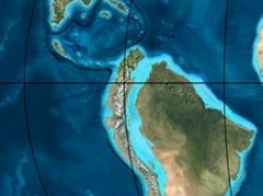
 Paleogeography of Northern South America 65 Ma, by Ron Blakey | |
The Guaduas Formation (Spanish: Formación Guaduas, K2P1G, K2E1G, KPgg, KTg, TKg, Ktg) is a geological formation of the Middle Magdalena Basin and the Altiplano Cundiboyacense, Eastern Ranges of the Colombian Andes. The predominantly shale with coalbed formation dates to the Late Cretaceous and Paleogene periods; Maastrichtian-Paleocene epochs, and has a maximum thickness of 1,090 metres (3,580 ft). Fossils of Coussapoa camargoi, Ficus andrewsi, Berhamniphyllum sp. and Archaeopaliurus boyacensis have been found in coalbeds in Zipaquirá and Tasco, Boyacá.