| Marine Corps Drive | ||||
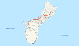
 GH-1 highlighted in red | ||||
| Route information | ||||
| Maintained by Guam DPW | ||||
| Length | 21.04 mi[2] (33.86 km) | |||
| Existed | c. 1941[1]–present | |||
| Major junctions | ||||
| West end | ||||
| ||||
| East end | ||||
| Location | ||||
| Country | United States | |||
| Territory | Guam | |||
| Highway system | ||||
| ||||
Guam Highway 1 (GH-1), also known as Marine Corps Drive, is one of the primary automobile routes in the United States territory of Guam. It runs in a southwest-to-northeast direction, from the main gate of Naval Base Guam in the southwestern village of Santa Rita in a northeasterly direction to the main gate of Andersen Air Force Base in the village of Yigo. It passes through Guam's capital, Hagåtña, as well as intersecting other territorial highways. The highway runs through tropical forest, urbanized commercial areas, and residential neighborhoods. The US military upgraded and extended the road starting in 1941. Construction ceased with the Japanese invasion in December 1941 and resumed after the Second Battle of Guam in 1944. The highway was formally dedicated to the U.S. Marine Corps by the governor in 2004.
- ^ Cite error: The named reference
npshistorywas invoked but never defined (see the help page). - ^ U.S. Census Bureau (January 1, 2006). "2006 Second Edition TIGER/Line File". U.S. Census Bureau. Retrieved February 19, 2008.
