Guatavita | |
|---|---|
Municipality and town | |
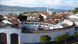
 Coliseum of Guatavita | |
 Location of the municipality and town of Guatavita in the Cundinamarca Department of Colombia | |
| Coordinates: 4°56′4″N 73°50′4″W / 4.93444°N 73.83444°W | |
| Country | |
| Department | |
| Province | Guavio Province |
| Founded | 18 March 1593 |
| Founded by | Miguel de Ibarra |
| Government | |
| • Mayor | Robeth Yamit Peña Romero (2016-2019) |
| Area | |
• Municipality and town | 247.3 km2 (95.5 sq mi) |
| • Urban | 6.84 km2 (2.64 sq mi) |
| Elevation | 2,680 m (8,790 ft) |
| Population (2015) | |
• Municipality and town | 6,898 |
| • Density | 28/km2 (72/sq mi) |
| • Urban | 1,960 |
| Time zone | UTC-5 (Colombia Standard Time) |
| Website | Official website |
Guatavita is a municipality and town of Colombia in the Guavio Province of the department of Cundinamarca. Guatavita is located 75 km northeast of the capital Bogotá. It borders Sesquilé and Machetá in the north, Gachetá and Junín in the east, Guasca in the south and in the west are Tocancipá and Gachancipá.[1]
- ^ (in Spanish) Official website Guatavita Archived 2016-01-30 at the Wayback Machine - accessed 05-05-2016


