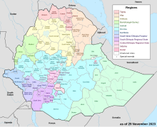
Guji (Oromo: Godina Gujii) is a zone in Oromia Region of Ethiopia. Guji is named after a tribe of the Oromo people. Guji is bordered on the south by Borena, on the west by the Southern Nations, Nationalities, and Peoples Region, on the north by the Ganale Dorya River which separates it from Bale and on the east by the Somali Region. The highest point in this zone is Mount Dara Tiniro. Cities and major towns in this Zone include its administrative center, Nagele, Shakiso Bore, Adola Woyu.
The Guji Zone was created in September 2002, when the upland woredas of the Borena Zone were split apart to create it.[1]
- ^ "Heavy rains in Borana and Guji Zones of Oromiya Region cause critical and potential water problems" Archived 2010-10-14 at the Wayback Machine UN-OCHA Report, June 2003 (accessed 16 January 2009) Although this source states the administrative change occurred September 2003, this is an understandable mistake because Ethiopian year starts in September.