Gulf, North Carolina | |
|---|---|
 | |
| Coordinates: 35°33′35″N 79°16′50″W / 35.55972°N 79.28056°W | |
| Country | United States |
| State | North Carolina |
| County | Chatham |
| Area | |
| • Total | 0.92 sq mi (2.38 km2) |
| • Land | 0.91 sq mi (2.35 km2) |
| • Water | 0.01 sq mi (0.03 km2) |
| Elevation | 266 ft (81 m) |
| Population (2020) | |
| • Total | 122 |
| • Density | 134.36/sq mi (51.85/km2) |
| Time zone | UTC-5 (Eastern (EST)) |
| • Summer (DST) | UTC-4 (EDT) |
| ZIP code | 27256 |
| FIPS code | 37-28600[3] |
| GNIS feature ID | 2628630[2] |
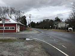
Gulf is an unincorporated community and census-designated place (CDP) in southwestern Chatham County, North Carolina, United States, southeast of the town of Goldston. As of the 2010 census, the Gulf CDP had a population of 144.[4] The community is home to a general store and several historic homes. It received its name from its location at a wide bend in the Deep River.
Gulf is an interconnection point between the Norfolk Southern Railway and the Aberdeen, Carolina and Western Railway.
- ^ "ArcGIS REST Services Directory". United States Census Bureau. Retrieved September 20, 2022.
- ^ a b U.S. Geological Survey Geographic Names Information System: Gulf, North Carolina
- ^ "U.S. Census website". United States Census Bureau. Retrieved January 31, 2008.
- ^ "Geographic Identifiers: 2010 Demographic Profile Data (G001): Gulf CDP, North Carolina". U.S. Census Bureau, American Factfinder. Archived from the original on February 12, 2020. Retrieved December 30, 2014.
