This article has multiple issues. Please help improve it or discuss these issues on the talk page. (Learn how and when to remove these messages)
|
9°17′46″N 78°20′39″W / 9.29611°N 78.34417°W
Guna Yala | |
|---|---|
 | |
| Coordinates: 9°33′N 78°58′W / 9.550°N 78.967°W | |
| Country | |
| Capital | Gaigirgordub |
| Area | |
| • Total | 2,358.2 km2 (910.5 sq mi) |
| Population (2023 census) | |
| • Total | 32,016[1] |
| GDP (PPP, constant 2015 values) | |
| • Year | 2023 |
| • Total | $100 million[2] |
| • Per capita | $4,500 |
| Time zone | UTC-5 (ETZ) |
| ISO 3166 code | PA-KY |
| HDI (2017) | 0.580[3] medium |

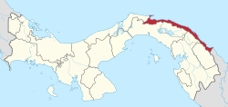
Guna Yala, formerly known as San Blas, is a comarca indígena (indigenous province) in northeast Panama. Guna Yala is home to the indigenous people known as the Gunas. Its capital is Gaigirgordub. It is bounded on the north by the Caribbean Sea, on the south by the Darién Province and Emberá-Wounaan, on the east by Colombia, and on the west by the province of Colón.
32,016 people lived here in 2023, with over 95% of them being indigenous peoples.[4]
- ^ "Cuadro 11. Superficie, población y densidad de población en la República, según Provincia, Comarca indígena, Distrito y Corregimiento: Censos de 1990, 2000 y 2010". Instituto Nacional de Estadística y Censo, Contraloría General de la República de Panamá. Retrieved 11 November 2016.
- ^ "TelluBase—Panama Fact Sheet (Tellusant Public Service Series)" (PDF). Tellusant. Retrieved 2024-01-11.
- ^ "Sub-national HDI - Area Database - Global Data Lab". hdi.globaldatalab.org. Retrieved 2018-09-13.
- ^ "Guna Yala (Indigenous Territory, Panama) - Population Statistics, Charts, Map and Location". www.citypopulation.de. Retrieved 2024-03-10.
