| Gundagai New South Wales | |||||||||||||||
|---|---|---|---|---|---|---|---|---|---|---|---|---|---|---|---|
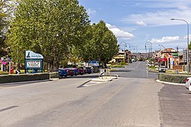
 Sheridan Street in 2019 | |||||||||||||||
 | |||||||||||||||
| Coordinates | 35°03′57″S 148°06′28″E / 35.065885°S 148.107695°E | ||||||||||||||
| Population | 2,057 (2021 census)[1] | ||||||||||||||
| Established | 1838 | ||||||||||||||
| Postcode(s) | 2722 | ||||||||||||||
| Elevation | 232 m (761 ft) | ||||||||||||||
| Location |
| ||||||||||||||
| LGA(s) | Cootamundra-Gundagai Regional Council | ||||||||||||||
| County | Clarendon | ||||||||||||||
| State electorate(s) | Cootamundra | ||||||||||||||
| Federal division(s) | Riverina | ||||||||||||||
| |||||||||||||||
| |||||||||||||||
Gundagai /ˈɡʌndəɡaɪ/[2] is a town in New South Wales, Australia. Although a small town, Gundagai is a popular topic for writers and has become a representative icon of a typical Australian country town.[3] Located along the Murrumbidgee River and Muniong, Honeysuckle, Kimo, Mooney Mooney, Murrumbidgee and Tumut mountain ranges, Gundagai is 390 kilometres (240 mi) south-west of Sydney. Until 2016, Gundagai was the administrative centre of Gundagai Shire local government area. In the 2021 census, the population of Gundagai was 2,057.[1]
- ^ a b Australian Bureau of Statistics (28 June 2022). "Gundagai (Urban Centre/Locality)". 2021 Census QuickStats. Retrieved 15 December 2022.
 Material was copied from this source, which is available under a Creative Commons Attribution 4.0 International License.
- ^ Macquarie Dictionary, Fourth Edition (2005). Melbourne, The Macquarie Library Pty Ltd. ISBN 1-876429-14-3
- ^ "Gundagai". The Sydney Morning Herald. 8 February 2004. Retrieved 8 May 2008.
