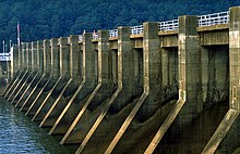
| Guntersville Dam | |
|---|---|
 Guntersville Dam | |
| Official name | Guntersville Dam |
| Location | Marshall County, Alabama, United States |
| Coordinates | 34°25′16″N 86°23′35″W / 34.42111°N 86.39306°W |
| Construction began | December 4, 1935 |
| Opening date | January 17, 1939 |
| Operator(s) | Tennessee Valley Authority |
| Dam and spillways | |
| Impounds | Tennessee River |
| Height | 94 ft (29 m) |
| Length | 3,979 ft (1,213 m) |
| Reservoir | |
| Creates | Guntersville Lake |
| Total capacity | 1,049,000 acre⋅ft (1,294,000 dam3)[1] |
| Catchment area | 24,450 sq mi (63,300 km2)[1] |
Guntersville Dam is a hydroelectric dam on the Tennessee River in Marshall County, in the U.S. state of Alabama. It is one of nine dams on the river owned and operated by the Tennessee Valley Authority, which built the dam in the late 1930s as part of a New Deal era initiative to create a continuous navigation channel on the entire length of the river and bring flood control and economic development to the region. The dam impounds the Guntersville Lake of 67,900 acres (27,500 ha), and its tailwaters feed into Wheeler Lake.
Guntersville Dam is named for the city of Guntersville, Alabama, which is located about 10 miles (16 km) upstream.[2] The city is named for its first settler, John Gunter (d. 1836), who arrived in the late 18th century.[3]
- ^ a b Cite error: The named reference
NPDPwas invoked but never defined (see the help page). - ^ Tennessee Valley Authority, The Guntersville Project: A Comprehensive Report on the Planning, Design, Construction, and Initial Operations of the Guntersville Project, Technical Report No. 4 (Knoxville, Tenn.: Tennessee Valley Authority, 1941), pp. 1-14, 44, 243, 256, 265.
- ^ Lake Guntersville Chamber of Commerce, History of Guntersville Archived 2009-02-03 at the Wayback Machine. Retrieved: 15 January 2009.