Gunzenhausen | |
|---|---|
 Protestant St. Mary's Church | |
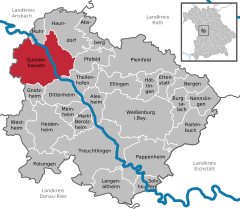
Location of Gunzenhausen within Weißenburg-Gunzenhausen district  | |
| Coordinates: 49°06′53″N 10°45′15″E / 49.11472°N 10.75417°E | |
| Country | Germany |
| State | Bavaria |
| Admin. region | Mittelfranken |
| District | Weißenburg-Gunzenhausen |
| Subdivisions | 14 Stadtteile |
| Government | |
| • Mayor (2020–26) | Karl-Heinz Fitz[1] (CSU) |
| Area | |
| • Total | 82.73 km2 (31.94 sq mi) |
| Elevation | 416 m (1,365 ft) |
| Population (2023-12-31)[2] | |
| • Total | 17,237 |
| • Density | 210/km2 (540/sq mi) |
| Time zone | UTC+01:00 (CET) |
| • Summer (DST) | UTC+02:00 (CEST) |
| Postal codes | 91710 |
| Dialling codes | 09831 |
| Vehicle registration | WUG, GUN |
| Website | gunzenhausen.de |
Gunzenhausen (German pronunciation: [ɡʊnt͡sn̩ˈhaʊ̯zn̩] ; Bavarian: Gunzenhausn) is a town in the Weißenburg-Gunzenhausen district, in Bavaria, Germany. It is situated on the river Altmühl, 19 kilometres (12 mi) northwest of Weißenburg in Bayern, and 45 kilometres (28 mi) southwest of Nuremberg. Gunzenhausen is a nationally recognized recreation area. It is noted as being at one end of part of The Limes Germanicus, a Roman border wall, and a UNESCO World Heritage Site.[3]
- ^ Liste der ersten Bürgermeister/Oberbürgermeister in kreisangehörigen Gemeinden, Bayerisches Landesamt für Statistik, 15 July 2021.
- ^ Genesis Online-Datenbank des Bayerischen Landesamtes für Statistik Tabelle 12411-003r Fortschreibung des Bevölkerungsstandes: Gemeinden, Stichtag (Einwohnerzahlen auf Grundlage des Zensus 2011).
- ^ "Franconian Lake Region". Franken Tourismus. Retrieved 23 March 2018.


