This article possibly contains original research. (June 2019) |
Gurdaspur district | |
|---|---|
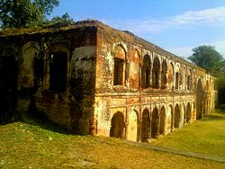
 Sujanpur Fort | |
 Location in Punjab | |
| Coordinates: 31°55′N 75°15′E / 31.917°N 75.250°E | |
| Country | |
| State | Punjab |
| Headquarters | Gurdaspur |
| Area | |
| • Total | 2,610 km2 (1,010 sq mi) |
| Population (2011)[‡] | |
| • Total | 2,298,323 |
| • Density | 880/km2 (2,300/sq mi) |
| Languages | |
| • Official | Punjabi |
| Time zone | UTC+5:30 (IST) |
| Vehicle Code | PB 06,PB 18,PB 58,PB 85, PB 99 |
| Literacy | 79.95% |
| Website | gurdaspur |
Gurdaspur district is a district in the Majha region of the state of Punjab, India. Gurdaspur is the district headquarters. It internationally borders Narowal District of Pakistani Punjab, and the districts of Amritsar, Pathankot, Kapurthala and Hoshiarpur. Two main rivers Beas and Ravi passes through the district. The Mughal emperor Akbar is said to have been enthroned in a garden near Kalanaur, a historically important town in the district.[1] The district is at the foothills of the Himalayas.
As of 2011 it is the third most populous district of Punjab (out of 22), after Ludhiana and Amritsar.[2] Batala, with 31% of the district's population, is its largest city.
- ^ "About District". gurdaspur.nic.in. Archived from the original on 2 August 2005. Retrieved 29 March 2018.
- ^ "District Census 2011". Census2011.co.in. 2011. Retrieved 30 September 2011.