Gwynfe
| |
|---|---|
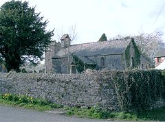
 Gwynfe Church and Church Hall in 2006 | |
Location within Carmarthenshire | |
| OS grid reference | SN720218 |
| Community | |
| Principal area | |
| Preserved county | |
| Country | Wales |
| Sovereign state | United Kingdom |
| Post town | Llangadog |
| Postcode district | SA19 |
| Police | Dyfed-Powys |
| Fire | Mid and West Wales |
| Ambulance | Welsh |
| UK Parliament | |
| Senedd Cymru – Welsh Parliament | |
Gwynfe () or Capel Gwynfe is a small village inside the portion of Brecon Beacons National Park that is in Carmarthenshire, a county of southwestern Wales. This village is situated between Trichrug and the western slopes of the Black Mountain, to the west of the A4069 road about halfway between Llangadog and Brynamman. The village comprises a scattered collection of mostly nineteenth and twentieth-century housing that developed around several chapels.[1] The area around the village is mainly farmland and the village was 2004 'Village of the Year for Carmarthenshire'.[2] The village has a grade-two listed phone box now used as an information centre and a modern community hall built in 2001. The community association have erected 2 large woodcarvings of three red kites.[3]
- ^ 233 LLANDDEUSANT - CAPEL-GWYNFE
- ^ "Llangadog, Capel Gwynfe and Bethlehem Community website". llangadog.com. 2014. Retrieved 5 September 2014.
- ^ Gwynfe Community Hall.
