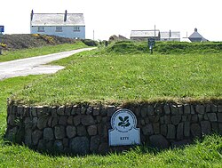
 Looking south from the car park at 'Kete'. A present-day view of the site of HMS Harrier
| |
| History | |
|---|---|
| Name | HMS Harrier |
| Commissioned | 1 February 1948 |
| Decommissioned | 2 January 1961 |
| General characteristics | |
| Class and type | Stone frigate |

HMS Harrier was a shore establishment of the Royal Navy, located at Kete, Pembrokeshire. It was commissioned on 1 February 1948 and was the home of the RN School of Aircraft Direction from the end of the Second World War, opened on 1 January 1945, until 1961, when the Aircraft Direction Officer Training returned to RNAS Yeovilton (HMS Heron). The site at Kete was ideal for air interception exercises, with the centre located 1 mile South of RNAS Dale (HMS Goldcrest), from where the live interception flights were provided from, and it had a wide sector over the sea.
The Aircraft Direction Centre was situated on the coast 0.5 miles (0.80 km) South East of the village of Dale and 0.25 miles (0.40 km) North of St. Anne's Head, the Western entrance point of Milford Haven waterway. The town of Milford Haven lies 5 miles (8.0 km) East, with Haverfordwest lying 11 miles (18 km) North East and Pembroke Dock lying 10 miles (16 km) South East.[1]