| Haditha Dam | |
|---|---|
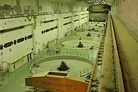
 Water outlet of the Haditha Dam | |
| Official name | سد حديثة |
| Location | Haditha, Al Anbar Governorate, Iraq |
| Coordinates | 34°12′25″N 42°21′18″E / 34.20694°N 42.35500°E |
| Construction began | 1977 |
| Opening date | 1987 |
| Construction cost | US$830,000,000 |
| Operator(s) | Ministry of Water Resources |
| Dam and spillways | |
| Impounds | Euphrates River |
| Height | 57 m (187 ft) |
| Length | 9,064 m (29,738 ft) |
| Reservoir | |
| Creates | Lake Qadisiyah |
| Total capacity | 8.3 km3 (2.0 cu mi) |
| Surface area | 500 km2 (193 sq mi) |
| Power Station | |
| Turbines | 6 |
| Installed capacity | 660 MW |

The Haditha Dam (Arabic: سد حديثة, romanized: Sadd Ḥadītha) or Qadisiya Dam is an earth-fill dam on the Euphrates, north of Haditha (Iraq), creating Lake Qadisiyah (Arabic: Buhayrat al-Qadisiyyah). The dam is just over 9 kilometres (5.6 mi) long and 57 metres (187 ft) high. The purpose of the dam is to generate hydroelectricity, regulate the flow of the Euphrates and provide water for irrigation. It is the second-largest hydroelectric contributor to the power system in Iraq behind the Mosul Dam.
