Haguenau
| |
|---|---|
Subprefecture and commune | |
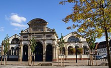
 The town hall in Haguenau | |
| Coordinates: 48°49′N 7°47′E / 48.82°N 7.79°E | |
| Country | France |
| Region | Grand Est |
| Department | Bas-Rhin |
| Arrondissement | Haguenau-Wissembourg |
| Canton | Haguenau |
| Intercommunality | CA Haguenau |
| Government | |
| • Mayor (2020–2026) | Claude Sturni [1] |
Area 1 | 182.59 km2 (70.50 sq mi) |
| Population (2021)[2] | 35,715 |
| • Density | 200/km2 (510/sq mi) |
| Time zone | UTC+01:00 (CET) |
| • Summer (DST) | UTC+02:00 (CEST) |
| INSEE/Postal code | 67180 /67500 |
| Elevation | 115–203 m (377–666 ft) (avg. 150 m or 490 ft) |
| 1 French Land Register data, which excludes lakes, ponds, glaciers > 1 km2 (0.386 sq mi or 247 acres) and river estuaries. | |

Haguenau (French: [aɡ(ə)no] ; Alsatian: Hàwenau [ˈhaːvənau̯] or Hàjenöi [ˈhaːjənœi̯]; German: Hagenau; historical English: Hagenaw) is a commune in the Bas-Rhin department of France, of which it is a sub-prefecture.[3]
It is second in size in the Bas-Rhin only to Strasbourg, some 30 km (19 mi) to the south. To the north of the town, the Forest of Haguenau is the largest undivided forest in France.
Haguenau was founded by German dukes and has swapped back and forth several times between Germany and France over the centuries, with its spelling altering between "Hagenau" and "Haguenau" by the turn. After the French defeat in the Franco-Prussian War, Haguenau was ceded to the new German Empire. It was part of the German Empire for 48 years from 1871 to 1918, when at the end of World War I it was returned to France. This transfer was officially ratified in 1919 with the Treaty of Versailles.
Haguenau is a rapidly growing town, its population having increased from 22,944 inhabitants in 1968 to 34,504 inhabitants in 2017.[4] Haguenau's functional urban area has grown from 54,415 inhabitants in 1968 to 75,933 inhabitants in 2017.[5]
- ^ "Répertoire national des élus: les maires". Plateforme ouverte des données publiques françaises (in French). 2 December 2020.
- ^ "Populations légales 2021" (in French). The National Institute of Statistics and Economic Studies. 28 December 2023.
- ^ "Commune de Haguenau (67180)" (in French). INSEE. Retrieved 21 August 2024.
- ^ "Évolution et structure de la population en 2017: Commune de Haguenau (67180)". INSEE (in French).
- ^ "Évolution et structure de la population en 2017: Aire d'attraction des villes 2020 de Haguenau (127)". INSEE (in French).


