| Hallikeld | |
|---|---|
| Wapentake | |
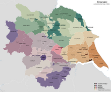
 Wapentakes of Yorkshire. Hallikeld is a light green colour just above Ripon. | |
| Area | |
| • Coordinates | 54°15′07″N 1°32′46″W / 54.252°N 1.546°W |
| Status | Defunct |
| Subdivisions | |
| • Type | 7 parishes (1914) |
Hallikeld[note 1] was a wapentake, an administrative division (or ancient district) analogous to a hundred,[2] in the historic county of the North Riding of Yorkshire. It was one of the smaller wapentakes by area and consisted of seven parishes.
- ^ "County: North Riding of Yorkshire, Halikeld wapentake. Grant description and date". discovery.nationalarchives.gov.uk (in Latin). Retrieved 4 February 2020.
- ^ "Hallikeld Wap through time | Census tables with data for the Ancient District". www.visionofbritain.org.uk. Retrieved 4 February 2020.
Cite error: There are <ref group=note> tags on this page, but the references will not show without a {{reflist|group=note}} template (see the help page).