| Halls Gap Budja Budja Victoria | |
|---|---|
 | |
| Coordinates | 37°07′0″S 142°33′0″E / 37.11667°S 142.55000°E |
| Population | 495 (2021 census)[1] |
| • Density | 6.505/km2 (16.847/sq mi) |
| Postcode(s) | 3381 |
| Area | 76.1 km2 (29.4 sq mi) |
| Time zone | AEST (UTC+10) |
| • Summer (DST) | AEDT (UTC+11) |
| Location |
|
| LGA(s) | |
| County | Borung |
| State electorate(s) | Lowan |
| Federal division(s) | Wannon |
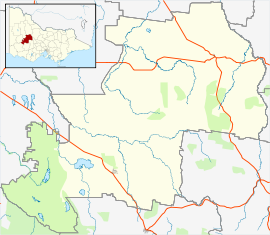
Halls Gap (Djab Wurrung/Jardwadjali: Budja Budja)[2] is a town in Victoria, Australia. It is located on Grampians Road, adjacent to the Grampians National Park, in the Shire of Northern Grampians local government area. The town is set in the Fyans Valley at the foot of the Wonderland and Mount William ranges.[3] At the 2021 census Halls Gap had a population of 495.[1] The approximate driving time from Melbourne is 3 hours.
- ^ a b "2021 Census QuickStats Halls Gap". Australian Bureau of Statistics. Retrieved 23 February 2024.
- ^ "Budja Budja Aboriginal Cooperative | Halls Gap | Gariwerd". Budja Budja Aboriginal Cooperative. Retrieved 27 December 2023.
- ^ "Visit Victoria". Halls Gap. Tourism Victoria. Retrieved 22 August 2011.
