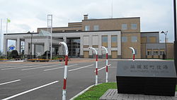
Hamatonbetsu
浜頓別町 | |
|---|---|
 Hamatonbetsu town hall | |
 Location of Hamatonbetsu in Hokkaido (Sōya Subprefecture) | |
 | |
| Coordinates: 45°7′26″N 142°21′35″E / 45.12389°N 142.35972°E | |
| Country | Japan |
| Region | Hokkaido |
| Prefecture | Hokkaido (Sōya Subprefecture) |
| District | Esashi |
| Area | |
| • Total | 401.59 km2 (155.05 sq mi) |
| Population (July 1, 2024) | |
| • Total | 3,263 |
| • Density | 8.1/km2 (21/sq mi) |
| Time zone | UTC+09:00 (JST) |
| City hall address | Chūō-Minami 1-ban, Hamatonbetsu-chō, Esashi-gun, Hokkaidō 098-5792 |
| Climate | Dfb |
| Website | Official website |
| Symbols | |
| Bird | Tundra swan |
| Flower | Caltha |
| Tree | Sakhalin Spruce |


Hamatonbetsu (浜頓別町, Hamatonbetsu-chō) is a town located in Sōya Subprefecture, Hokkaido, Japan.[1] As of 1 July 2024[update], the town had an estimated population of 3,263 in 1841 households, and a population density of 8.1 people per km2.[2] The total area of the town is 401.59 km2 (155.05 sq mi).
- ^ Cite error: The named reference
nwas invoked but never defined (see the help page). - ^ "Hamatonbetsu Town official statistics" (in Japanese). Japan.


