Hamdallaye, Niger | |
|---|---|
Commune and village | |
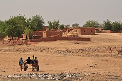
 Children with donkey cart in Hamdallaye | |
| Coordinates: 13°33′25″N 02°24′26″E / 13.55694°N 2.40722°E | |
| Country | |
| Region | Tillabéri Region |
| Department | Kollo Department |
| Area | |
| • Total | 683 sq mi (1,769 km2) |
| Population (2012) | |
| • Total | 57,002 |
| • Density | 83/sq mi (32/km2) |
| Time zone | UTC+1 (WAT) |
Hamdallaye is a village and rural commune in Niger. In 2012, it had a registered population of 57,002 inhabitants.[1] It is located in the southwest of the country, near the Niger River, the border with Mali and Burkina Faso and the national capital, Niamey. It is the location of a U.S. Peace Corps training site,[2] a weekly market and a mosque.
- ^ "Niger: Municipal Division (Departments and Communes) - Population Statistics, Charts and Map". www.citypopulation.de. Archived from the original on 2021-12-29. Retrieved 2022-02-15.
- ^ "Peace Corps Mourns the Loss of Volunteer Stephanie Chance". www.peacecorps.gov. Archived from the original on 2022-02-16. Retrieved 2022-02-16.
