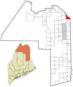
Hamlin, Maine | |
|---|---|
 Location of Hamlin, Maine | |
| Coordinates: 47°5′31″N 67°50′55″W / 47.09194°N 67.84861°W | |
| Country | United States |
| State | Maine |
| County | Aroostook |
| Area | |
| • Total | 24.04 sq mi (62.26 km2) |
| • Land | 23.35 sq mi (60.48 km2) |
| • Water | 0.69 sq mi (1.79 km2) |
| Elevation | 659 ft (201 m) |
| Population (2020) | |
| • Total | 166 |
| • Density | 7/sq mi (2.7/km2) |
| Time zone | UTC-5 (Eastern (EST)) |
| • Summer (DST) | UTC-4 (EDT) |
| Area code | 207 |
| FIPS code | 23-30690 |
| GNIS feature ID | 0582506 |
Hamlin is a town in Aroostook County, Maine, United States. It is located on the Canada–US border with a border crossing into Grand Falls, New Brunswick and is the closest continental location to Europe in the United States.[2] Hamlin's northeastern corner is the closest point in the mainland United States to Western Europe, situated at a distance of 2,508 miles (4,018 km) from the closest point in Europe to the USA, Achill Head.[3] The population was 166 at the 2020 census.[4]
- ^ "US Gazetteer files 2010". United States Census Bureau. Retrieved December 16, 2012.
- ^ "The closest point in the United States to Europe". www.acscdg.com. Archived from the original on September 18, 2015. Retrieved September 8, 2015.
- ^ "The closest point in the United States to Europe". www.acscdg.com. Retrieved March 20, 2021.
- ^ "Census - Geography Profile: Hamlin town, Aroostook County, Maine". Retrieved March 12, 2022.