Hancock, New Hampshire | |
|---|---|
Town | |
 Town Hall | |
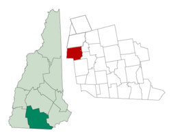
 Location in Hillsborough County, New Hampshire | |
| Coordinates: 42°58′22″N 71°58′47″W / 42.97278°N 71.97972°W | |
| Country | United States |
| State | New Hampshire |
| County | Hillsborough |
| Incorporated | 1779 |
| Government | |
| • Selectboard |
|
| • Town Administrator | Jonathan Coyne |
| Area | |
| • Total | 31.2 sq mi (80.9 km2) |
| • Land | 30.0 sq mi (77.6 km2) |
| • Water | 1.3 sq mi (3.3 km2) 4.12% |
| Elevation | 876 ft (267 m) |
| Population (2020)[2] | |
| • Total | 1,731 |
| • Density | 58/sq mi (22.3/km2) |
| Time zone | UTC-5 (Eastern) |
| • Summer (DST) | UTC-4 (Eastern) |
| ZIP code | 03449 |
| Area code | 603 |
| FIPS code | 33-33700 |
| GNIS feature ID | 0873618 |
| Website | www |
Hancock is a town in Hillsborough County, New Hampshire, United States. The population was 1,731 at the 2020 census.[2] Hancock is home to the Welch Family Farm Forest.
The main village of the town, where 213 people resided at the 2020 census, is defined as the Hancock census-designated place (CDP), and is located at the junction of New Hampshire routes 123 and 137.
- ^ "2021 U.S. Gazetteer Files – New Hampshire". United States Census Bureau. Retrieved December 7, 2021.
- ^ a b "Hancock town, Hillsborough County, New Hampshire: 2020 DEC Redistricting Data (PL 94-171)". U.S. Census Bureau. Retrieved December 7, 2021.