Handeni
Wilaya ya Handeni (Swahili) | |
|---|---|
| Wilaya ya Handeni, Mkoa wa Tanga | |
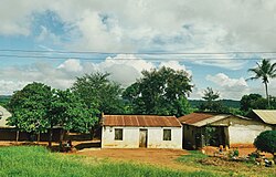
 Manga Village, Mkata Ward, Handeni District | |
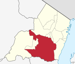
 Handeni District in Tanga 2022 | |
| Coordinates: 5°30′32.76″S 38°20′20.04″E / 5.5091000°S 38.3389000°E | |
| Country | |
| Region | Tanga Region |
| Capital | Mkata |
| Area | |
| • Total | 6,534 km2 (2,523 sq mi) |
| • Rank | 1/11 |
| Population (2022 census) | |
| • Total | 384,353 |
| • Density | 59/km2 (150/sq mi) |
| Demonym | Handenian |
| Ethnic groups | |
| • Settler | Swahili |
| • Native | Zigua |
| Website | www |

Handeni District is one of the 11 districts of Tanga Region in Tanzania. The District covers an area of 6,534 km2 (2,523 sq mi).[1] It is bordered to the west by the Kilindi District and the Handeni Urban District, to the north by the Korogwe District, to the east by the Pangani District, and to the south by the Pwani Region. In 2002 Kilindi District was formed out of the district. The administrative capital of the district is Mkata town. According to the 2002 Tanzania National Census, the population of the Handeni District was 248,633.[2] According to the 2022 census, the population had increased to: 384,353.[3][4]
- ^ "Tanzania: Northern Zone(Districts and Wards) - Population Statistics, Charts and Map".
- ^ "Archived copy". Archived from the original on 9 August 2007. Retrieved 18 September 2007.
{{cite web}}: CS1 maint: archived copy as title (link) - ^ "Tanzania: Administrative Division (Regions and Districts) - Population Statistics, Charts and Map". www.citypopulation.de. Retrieved 11 February 2024.
- ^ "2012 Population and Housing Census" (PDF). Development Partners Group Tanzania. Archived from the original (PDF) on 29 March 2018. Retrieved 7 August 2019.