This article possibly contains original research. (January 2009) |
Hari Hari | |
|---|---|
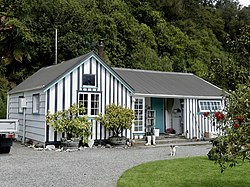
 Hende's Ferry Cottage, a historic building by the bank of the Wanganui River in Hari Hari | |
 | |
| Coordinates: 43°9′0″S 170°33′43″E / 43.15000°S 170.56194°E | |
| Country | New Zealand |
| Region | West Coast |
| District | Westland District |
| Ward | Southern |
| Electorates | |
| Government | |
| • Territorial Authority | Westland District Council |
| • Regional council | West Coast Regional Council |
| • Mayor of Westland | Helen Lash |
| • West Coast-Tasman MP | Maureen Pugh |
| • Te Tai Tonga MP | Tākuta Ferris |
| Area | |
| • Total | 50.43 km2 (19.47 sq mi) |
| Population (June 2024)[2] | |
| • Total | 270 |
| • Density | 5.4/km2 (14/sq mi) |
| Time zone | UTC+12 (NZST) |
| • Summer (DST) | UTC+13 (NZDT) |
| Postcode | 7884 |
| Area code | 03 |
| Local iwi | Ngāi Tahu |

Hari Hari (sometimes spelled Harihari) is a small rural settlement in the south west of the West Coast region of New Zealand's South Island. It is slightly inland from the Tasman Sea and the Saltwater Lagoon and is situated between the Wanganui and Poerua Rivers, 45 minutes south of the tourist town of Hokitika. State Highway 6 passes through the town on its route from Ross to the Franz Josef Glacier. The Westland District's largest town, Greymouth is 110 kilometres (68 mi), and Hokitika 70 km (43 mi) to the north-east. Ross is 46 km (29 mi) to the north-east, and Franz Josef is 32 km south west.[3][4]
Hari Hari was once a logging settlement and relics of a bush tramway that used to carry timber can be found in the area. Today, the forest in the area is protected and popular activities in the Hari Hari area include bushwalking, birdwatching, and trout and salmon fishing.
The Inter-Wanganui Co-op opened a dairy factory at Hari Hari in 1908,[5] but it is now a ruin.[6]
Hari Hari's main claim to fame occurred on 7 January 1931, when Australian aviator Guy Menzies landed upside down in a swamp near Hari Hari, completing the first solo flight across the Tasman Sea. Menzies, who had left Sydney 11 hours and 45 minutes earlier, was aiming for Blenheim but had been blown off course and mistook a swamp for flat pasture suitable for landing. Despite the accident, he was unharmed. On 7 January 2006, the 75th anniversary celebrations of the feat were held in Hari Hari, with roughly 400 people in attendance. To mark the occasion, Dick Smith recreated Guy Menzies' flight, though Smith chose to land upright in Hari Hari.[7]
- ^ Cite error: The named reference
Areawas invoked but never defined (see the help page). - ^ "Aotearoa Data Explorer". Statistics New Zealand. Retrieved 26 October 2024.
- ^ Peter Dowling, ed. (2004). Reed New Zealand Atlas. Reed Books. map 74. ISBN 0-7900-0952-8.
- ^ Roger Smith, GeographX (2005). The Geographic Atlas of New Zealand. Robbie Burton. map 164. ISBN 1-877333-20-4.
- ^ "Inter-Wanganui Co-op dairy factory opening". University of Canterbury library. Retrieved 5 August 2008.
- ^ "Inter-Wanganui Co-op Dairy Co". Panoramio. Retrieved 5 August 2008.
- ^ "Dick Smith recreates first solo trans-Tasman flight". Sydney Morning Herald. 8 January 2006.