| Harricana | |
|---|---|
 The Harricana River in Amos | |
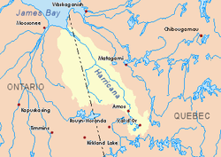
 Harricana River basin in yellow | |
| Location | |
| Country | Canada |
| Provinces | |
| Physical characteristics | |
| Source | Lake Blouin |
| • location | Val-d'Or, Jamésie, Quebec |
| • coordinates | 48°11′45″N 77°44′50″W / 48.19583°N 77.74722°W |
| Mouth | Hannah Bay off James Bay |
• location | 60 km east of Moosonee, Ontario |
• coordinates | 51°10′00″N 79°47′30″W / 51.16667°N 79.79167°W |
• elevation | 0 m (0 ft) |
| Length | 533 km (331 mi)[1] |
| Basin size | 29,300 km2 (11,300 sq mi)[1] |
| Discharge | |
| • average | 570 m3/s (20,000 cu ft/s)[1] |
The Harricana River (French: Rivière Harricana) (also known as Harricanaw River[2]) is a river in western Quebec and northeastern Ontario, Canada.[3] It is 533 kilometres (331 mi) long, has a drainage area of 29,300 square kilometres (11,300 sq mi), and has a mean discharge of 570 cubic metres per second (20,000 cu ft/s).[1] While 80% of its drainage area is in Quebec,[4] the river flows for a short distance through Ontario before it ends in Hannah Bay off James Bay.
Because of its undeveloped nature, easy upstream access, and the possibility to paddle to and take out at Moosonee, the Harricana River is popular for canoeing trips to James Bay.
- ^ a b c d "Atlas of Canada". Archived from the original on 2008-10-14. Retrieved 2007-01-23.
- ^ "Harricanaw River". Geographical Names Data Base. Natural Resources Canada.
- ^ "Harricana River". Geographical Names Data Base. Natural Resources Canada.
- ^ "Rivière Harricana" (in French). Commission de toponymie du Québec. Archived from the original on 2016-03-03. Retrieved 2008-11-18.