This article needs additional citations for verification. (February 2012) |
| Harrington | |
|---|---|
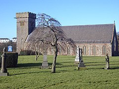
 St Mary's Parish Church, Harrington | |
| Population | 3,167 (Ward, 2011) |
| OS grid reference | NX985255 |
| Civil parish | |
| Unitary authority | |
| Ceremonial county | |
| Region | |
| Country | England |
| Sovereign state | United Kingdom |
| Post town | WORKINGTON |
| Postcode district | CA14 |
| Dialling code | 01946 |
| Police | Cumbria |
| Fire | Cumbria |
| Ambulance | North West |
| UK Parliament | |
Harrington is a village and former civil parish, now in the parish of Workington, in the Cumberland district, in the ceremonial county of Cumbria, England. It is on the Cumbrian coast south of Workington and north of Whitehaven. Historically part of Cumberland, its industrial history, which largely ended in the late 1930s, included a shipbuilders, iron works, coal mining and steel making. It once had five railway stations. It still has one railway station, on the Cumbrian Coast Line, near the harbour.
Today, with a population of approximately 3,800,[1] measured at 3,167 in the 2011 Census,[2] it is largely a dormitory village for the employees of the shops and offices and light industry found in Workington. Whitehaven, and Sellafield further down the coast.
The parish consisted of Harrington itself, High Harrington and Salterbeck, which is a large housing estate on the Workington side of the parish.
- ^ Harrington - Ward Profile , Cumbria Intelligence Observatory
- ^ "Workington Ward 2011". Retrieved 18 June 2015.

