Hautes-Alpes
Auts Aups (Occitan) | |
|---|---|
|
Top down, left to right: Massif des Cerces, prefecture building in Gap, Barre des Écrins, Lac de Serre-Ponçon and waterfall in the Vallée de la Clarée | |
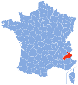
 Location of Hautes-Alpes in France | |
| Coordinates: 44°40′N 6°20′E / 44.667°N 6.333°E | |
| Country | France |
| Region | Provence-Alpes-Côte d'Azur |
| Prefecture | Gap |
| Subprefectures | Briançon |
| Government | |
| • President of the Departmental Council | Jean-Marie Bernard[1] (LR) |
| Area | |
| • Total | 5,549 km2 (2,142 sq mi) |
| Elevation | 1,665 m (5,463 ft) |
| Highest elevation | 4,101 m (13,455 ft) |
| Lowest elevation | 470 m (1,540 ft) |
| Population (2021)[2] | |
| • Total | 140,976 |
| • Rank | 100th |
| • Density | 25/km2 (66/sq mi) |
| Time zone | UTC+1 (CET) |
| • Summer (DST) | UTC+2 (CEST) |
| Department number | 05 |
| Arrondissements | 2 |
| Cantons | 15 |
| Communes | 162 |
| ^1 French Land Register data, which exclude estuaries and lakes, ponds and glaciers larger than 1 km2 | |
Hautes-Alpes (French pronunciation: [ot.z‿alp] ; Occitan: Auts Aups; English: Upper Alps) is a department in the Provence-Alpes-Côte d'Azur region of Southeastern France. It is located in the heart of the French Alps, after which it is named. Hautes-Alpes had a population of 141,220 as of 2019,[3] which makes it the third least populated French department. Its prefecture is Gap; its sole subprefecture is Briançon. Its INSEE and postal code is 05.
- ^ "Répertoire national des élus: les conseillers départementaux". data.gouv.fr, Plateforme ouverte des données publiques françaises (in French). 4 May 2022.
- ^ "Téléchargement du fichier d'ensemble des populations légales en 2021" (in French). The National Institute of Statistics and Economic Studies. 28 December 2023.
- ^ Populations légales 2019: 05 Hautes-Alpes, INSEE


