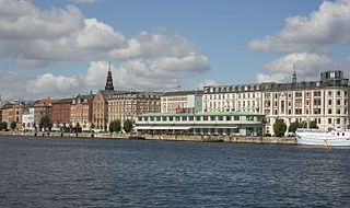
 Havnegade seen from Papirøen | |
| Length | 750 m (2,460 ft) |
|---|---|
| Location | Indre By, Copenhagen, Denmark |
| Postal code | 1058 |
| Nearest metro station | Kongens Nytorv |
| Coordinates | 55°40′38″N 12°35′26″E / 55.67722°N 12.59056°E |
| Qest end | Golmens Kanal |
| Major junctions | Niels Juels Gade, Tordenskjoldsgade, Peder Skrams Gade, Cort Adelers Gade, Herluf Trolles Gade |
| East end | Nyhavn |
Havnegade is a waterfront promenade in central Copenhagen, Denmark, which runs along the Inner Harbour between Knippelsbro and the mouth of the Nyhavn canal. Most of the street is lined with buildings from the 1860s and 1870s that were constructed as part of the redevelopment of the Gammelholm naval dockyards. It is the only place along Copenhagen's main harbourfront where residential buildings of that age face the water, although older warehouses and other industrial buildings elsewhere have been converted into residential use. The Modernist Bank of Denmark building is located at the western end of the street.