Hawthorne Municipal Airport Jack Northrop Field | |||||||||||
|---|---|---|---|---|---|---|---|---|---|---|---|
&sq=Facebook&lang=en&file=File:Hawthorne_Municipal_Airport_-_California.jpg) 1994 USGS photo | |||||||||||
| Summary | |||||||||||
| Airport type | Public | ||||||||||
| Owner/Operator | City of Hawthorne | ||||||||||
| Location | Hawthorne, California | ||||||||||
| Elevation AMSL | 66 ft / 20 m | ||||||||||
| Coordinates | 33°55′22″N 118°20′07″W / 33.92278°N 118.33528°W | ||||||||||
| Website | cityofhawthorne | ||||||||||
| Maps | |||||||||||
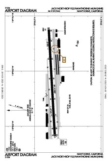 FAA airport diagram | |||||||||||
&sq=Facebook&lang=en&file=File:Relief_map_of_California.png) HHR Location &sq=Facebook&lang=en&file=File:Usa_edcp_relief_location_map.png) HHR HHR (the United States) | |||||||||||
| Runways | |||||||||||
| |||||||||||
Hawthorne Municipal Airport (IATA: HHR, ICAO: KHHR) (also known as Jack Northrop Field) is a public use airport in Hawthorne, California, United States. It is owned by the City of Hawthorne.