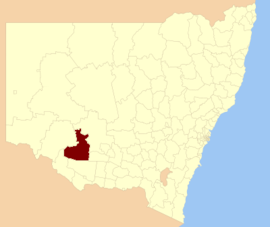
| Hay Shire New South Wales | |||||||||||||||
|---|---|---|---|---|---|---|---|---|---|---|---|---|---|---|---|
 Location in New South Wales | |||||||||||||||
| Coordinates | 34°30′S 144°51′E / 34.500°S 144.850°E | ||||||||||||||
| Population | 2,884 (2021 census)[1] | ||||||||||||||
| • Density | 0.25464/km2 (0.65951/sq mi) | ||||||||||||||
| Established | 1 January 1965 | ||||||||||||||
| Area | 11,325.89 km2 (4,373.0 sq mi)[2] | ||||||||||||||
| Mayor | Cr. Carol Oataway (Unaligned)[3] | ||||||||||||||
| Council seat | Hay | ||||||||||||||
| Region | Riverina | ||||||||||||||
| State electorate(s) | Murray | ||||||||||||||
| Federal division(s) | Farrer | ||||||||||||||
 | |||||||||||||||
| Website | Hay Shire | ||||||||||||||
| |||||||||||||||
The Hay Shire is a local government area in the Riverina area of south-western New South Wales, Australia. The Shire comprises 11,326 square kilometres (4,373 sq mi) and is located adjacent to the Sturt, Mid-western and Cobb Highways. The area includes the towns of Hay, Booligal and Maude.
Hay Shire was established in 1965 by the amalgamation of the Municipality of Hay with the surrounding Waradgery Shire.[4]
The mayor of Hay Shire is Cr. Carol Oataway, an unaligned politician who had previously held the position of Principal of Hay Public School.[3][5]
- ^ Australian Bureau of Statistics (28 June 2022). "Hay". 2021 Census QuickStats. Retrieved 25 September 2023.
- ^ "Hay Regional Profile". Riverina Regional Development Board. Archived from the original on 19 July 2008. Retrieved 28 August 2008.
- ^ a b Cite error: The named reference
mayorwas invoked but never defined (see the help page). - ^ "Waradgery Shire Council". Search. State Records NSW. Retrieved 21 May 2016.
- ^ Ian Beissel (2019), Hay Public School: 150 Years of History 1869-2019, Hay Historical Society, page 175.