Hazelwood | |
|---|---|
| City of Hazelwood | |
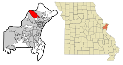
 Location of Hazelwood, Missouri | |
| Coordinates: 38°46′46″N 90°21′23″W / 38.77944°N 90.35639°W | |
| Country | United States |
| State | Missouri |
| County | St. Louis |
| Incorporated | 1949 |
| Government | |
| • Mayor | Matthew G. Robinson |
| • City Council |
|
| • City Manager | Matthew Zimmerman |
| Area | |
| • Total | 16.76 sq mi (43.42 km2) |
| • Land | 16.04 sq mi (41.54 km2) |
| • Water | 0.72 sq mi (1.88 km2) |
| Elevation | 469 ft (143 m) |
| Population (2020) | |
| • Total | 25,458 |
| • Density | 1,587.36/sq mi (612.87/km2) |
| Time zone | UTC−6 (Central (CST)) |
| • Summer (DST) | UTC−5 (CDT) |
| ZIP code | 63042 |
| Area code | 314 |
| FIPS code | 29-31276[3] |
| GNIS feature ID | 2394341[2] |
| Website | www.hazelwoodmo.org |
Hazelwood is a city in St. Louis County, Missouri, within Greater St. Louis. It is a second-ring northern suburb of St. Louis. Based on the 2020 United States census, the city had a total population of 25,485.[4] It is located north of St. Louis-Lambert International Airport and is situated on Interstates 270 and 170, as well as the much-traveled Lindbergh Boulevard and Highway 370.
- ^ "ArcGIS REST Services Directory". United States Census Bureau. Retrieved August 28, 2022.
- ^ a b U.S. Geological Survey Geographic Names Information System: Hazelwood, Missouri
- ^ "U.S. Census website". United States Census Bureau. Retrieved January 31, 2008.
- ^ "Explore Census Data".
