This article needs additional citations for verification. (September 2014) |
| Heart River | |
|---|---|
 The Heart River, near Mandan, North Dakota, 1949. | |
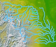
 A map of the Missouri River watershed, highlighting the Heart River. | |
| Location | |
| Country | United States |
| State | North Dakota |
| Physical characteristics | |
| Source | Near Saddle Butte |
| • location | Belfield, Billings County |
| • coordinates | 46°56′13″N 103°13′49″W / 46.93694°N 103.23028°W[1] |
| • elevation | 2,740 ft (840 m) |
| Mouth | Missouri River |
• location | Mandan, Morton County |
• coordinates | 46°46′03″N 100°50′31″W / 46.76750°N 100.84194°W[1] |
• elevation | 1,624 ft (495 m) |
| Length | 180 mi (290 km) |
| Basin size | 3,370 sq mi (8,700 km2)[2] |
| Discharge | |
| • location | Mandan, about 3 mi (4.8 km) above the mouth[3] |
| • average | 269 cu ft/s (7.6 m3/s)[4] |
| • minimum | 0 cu ft/s (0 m3/s) |
| • maximum | 30,500 cu ft/s (860 m3/s) |
| Basin features | |
| Tributaries | |
| • left | Green River, Missouri River |
The Heart River is a tributary of the Missouri River, approximately 180 miles (290 km) long, in western North Dakota, United States.[1]
- ^ a b c U.S. Geological Survey Geographic Names Information System: Heart River
- ^ "Boundary Descriptions and Names of Regions, Subregions, Accounting Units and Cataloging Units". U.S. Geological Survey. Retrieved 2013-01-31.
- ^ "USGS Gage #06349000 on the Heart River near Mandan, ND" (PDF). National Water Information System. U.S. Geological Survey. 1924–2011. Retrieved 2013-01-31.
- ^ "USGS Gage #06349000 on the Heart River near Mandan, ND" (PDF). National Water Information System. U.S. Geological Survey. 1924–2011. Retrieved 2013-01-31.