| Heathfield and Waldron | |
|---|---|
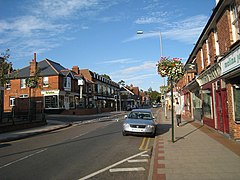
 Heathfield High Street | |
Location within East Sussex | |
| Area | 52.8 km2 (20.4 sq mi) [1] |
| Population | 11,913 (2011)[2] |
| • Density | 565/sq mi (218/km2) |
| OS grid reference | TQ586209 |
| • London | 40 miles (64 km) NNW |
| District | |
| Shire county | |
| Region | |
| Country | England |
| Sovereign state | United Kingdom |
| Post town | HEATHFIELD |
| Postcode district | TN21 |
| Dialling code | 01435 |
| Police | Sussex |
| Fire | East Sussex |
| Ambulance | South East Coast |
| UK Parliament | |
| Website | http://www.hwpc.org.uk/ |
Heathfield and Waldron is a civil parish[3] within the Wealden District of East Sussex, England. Heathfield is surrounded by the High Weald Area of Outstanding Natural Beauty. The parish was formed on 1 April 1999 from "Heathfield" and "Waldron" parishes.[4]
- ^ "East Sussex in Figures". East Sussex County Council. Retrieved 26 April 2008.
- ^ "Civil Parish population 2011". Retrieved 8 October 2015.
- ^ Parish website
- ^ "The Wealden (Parishes) Order 1990" (PDF). Local Government Boundary Commission for England. Archived from the original (PDF) on 3 February 2023. Retrieved 3 February 2023.
