This article needs additional citations for verification. (July 2024) |
Heemskerk | |
|---|---|
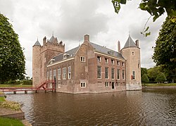
 Assumburg castle in Heemskerk | |
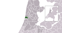
 Location in North Holland | |
| Coordinates: 52°31′N 4°40′E / 52.517°N 4.667°E | |
| Country | Netherlands |
| Province | North Holland |
| Region | Amsterdam metropolitan area |
| Government | |
| • Body | Municipal council |
| • Mayor | K. S. Heldoorn (Labour Party) |
| Area | |
| • Total | 31.68 km2 (12.23 sq mi) |
| • Land | 27.34 km2 (10.56 sq mi) |
| • Water | 4.34 km2 (1.68 sq mi) |
| Elevation | 2 m (7 ft) |
| Population (January 2021)[4] | |
| • Total | 39,191 |
| • Density | 1,433/km2 (3,710/sq mi) |
| Demonym | Heemskerker |
| Time zone | UTC+1 (CET) |
| • Summer (DST) | UTC+2 (CEST) |
| Postcode | 1960–1969 |
| Area code | 0251 |
| Website | www |
Heemskerk (Dutch pronunciation: [ˈɦeːmskɛr(ə)k] or [ɦeːmsˈkɛr(ə)k])[5] is a municipality and a town in the Netherlands, in the province of North Holland. It is located in the Kennemerland region.
- ^ "De burgemeester van Heemskerk" [The mayor of Heemskerk] (in Dutch). Gemeente Heemskerk. Archived from the original on 20 April 2016. Retrieved 5 March 2014.
- ^ "Kerncijfers wijken en buurten 2020" [Key figures for neighbourhoods 2020]. StatLine (in Dutch). CBS. 24 July 2020. Retrieved 19 September 2020.
- ^ "Postcodetool for 1964EZ". Actueel Hoogtebestand Nederland (in Dutch). Het Waterschapshuis. Archived from the original on 21 September 2013. Retrieved 5 March 2014.
- ^ "Bevolkingsontwikkeling; regio per maand" [Population growth; regions per month]. CBS Statline (in Dutch). CBS. 1 January 2021. Retrieved 2 January 2022.
- ^ Portret van Heemskerk (in Dutch). 2020-05-04. Retrieved 2024-10-26 – via YouTube.

