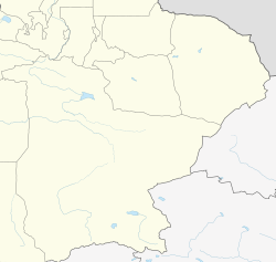
Hejing County
| |
|---|---|
 Hejing County (red) within Bayingolin Prefecture (yellow) and Xinjiang | |
| Coordinates: 42°18′59″N 86°22′58″E / 42.31639°N 86.38278°E | |
| Country | China |
| Autonomous region | Xinjiang |
| Autonomous prefecture | Bayingolin |
| County seat | Hejing Town |
| Area | |
| • Total | 34,978.89 km2 (13,505.42 sq mi) |
| Population (2020)[1] | |
| • Total | 147,859 |
| • Density | 4.2/km2 (11/sq mi) |
| Time zone | UTC+8 (China Standard[a]) |
| Website | www |
| Hejing County | |||||||||||
|---|---|---|---|---|---|---|---|---|---|---|---|
| Chinese name | |||||||||||
| Simplified Chinese | 和静县 | ||||||||||
| Traditional Chinese | 和靜縣 | ||||||||||
| |||||||||||
| Mongolian name | |||||||||||
| Mongolian Cyrillic | Хэжин шянь | ||||||||||
| Mongolian script | ᠾᠧᠵᠢᠩ ᠰᠢᠶᠠᠨ | ||||||||||
| Uyghur name | |||||||||||
| Uyghur | خېجىڭ ناھىيىسى | ||||||||||
| |||||||||||
Hejing County is located in the central-southern part of the Tian Shan mountains of Xinjiang, in the north-west of Bayingolin Mongol Autonomous Prefecture. The northernmost county-level division of Bayingolin, it borders Ürümqi City to the north, from which it is 190 km (120 mi) as the crow flies, and Korla City (the prefectural capital) to the south, which is 80 km (50 mi) away. It borders 15 cities and counties and is the most bordered county in the world.[citation needed]
Cite error: There are <ref group=lower-alpha> tags or {{efn}} templates on this page, but the references will not show without a {{reflist|group=lower-alpha}} template or {{notelist}} template (see the help page).


