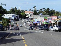
Helensville | |
|---|---|
 | |
 | |
| Coordinates: 36°40′47″S 174°26′58″E / 36.67972°S 174.44944°E | |
| Country | New Zealand |
| Region | Auckland |
| Ward | Rodney ward |
| Community board | Rodney Local Board |
| Subdivision | Kumeū subdivision |
| Electorates | |
| Government | |
| • Territorial Authority | Auckland Council |
| Area | |
• Total | 4.05 km2 (1.56 sq mi) |
| Population (June 2024)[2] | |
• Total | 3,420 |
| • Density | 840/km2 (2,200/sq mi) |
| Postcode(s) | 0800 |
Helensville (Māori: Te Awaroa)[3] is a town in the North Island of New Zealand. It is sited 40 kilometres (25 mi) northwest of Auckland, close to the southern extremity of the Kaipara Harbour. State Highway 16 passes through the town, connecting it to Waimauku 16 kilometres (10 mi) to the south, and Kaukapakapa about 12 kilometres (7.5 mi) to the north-east. Parakai is two kilometres (1.2 mi) to the north-west. The Kaipara River runs through the town and into the Kaipara Harbour to the north.
Tāmaki Māori settled the southern Kaipara Harbour in the 13th or 14th centuries, drawn by the marine and forest resources. The upper reaches of the Kaipara River was the location of Te Tōangaroa, a portage where waka could be hauled between the Kaipara Harbour and the Waitematā Harbour. By the 15th century, the area had become home to some of the earliest pā sites in the Auckland Region. By the early 18th century, Ngāti Whātua, who had traditional ties to the area, had re-established themselves along the Kaipara River.
Helensville was established as a kauri logging settlement in 1862, developing into a regional centre for the south Kaipara by the 1870s. Helensville became a major centre for the dairy industry between 1911 and the 1980s.
- ^ Cite error: The named reference
Areawas invoked but never defined (see the help page). - ^ "Aotearoa Data Explorer". Statistics New Zealand. Retrieved 26 October 2024.
- ^ Cite error: The named reference
Historywas invoked but never defined (see the help page).