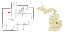
Hemlock, Michigan | |
|---|---|
 Looking west along M-46 at N. Hemlock Road | |
 Location within Saginaw County | |
| Coordinates: 43°25′07″N 84°13′52″W / 43.41861°N 84.23111°W[1] | |
| Country | United States |
| State | Michigan |
| County | Saginaw |
| Township | Richland |
| Area | |
| • Total | 2.78 sq mi (7.19 km2) |
| • Land | 2.75 sq mi (7.13 km2) |
| • Water | 0.02 sq mi (0.06 km2) |
| Elevation | 650 ft (200 m) |
| Population (2020) | |
| • Total | 1,408 |
| • Density | 511.63/sq mi (197.55/km2) |
| Time zone | UTC-5 (Eastern (EST)) |
| • Summer (DST) | UTC-4 (EDT) |
| ZIP code(s) | 48626 |
| Area code | 989 |
| FIPS code | 26-37600[3] |
| GNIS feature ID | 2393046[1] |
Hemlock is an unincorporated community in Richland Township, Saginaw County in the U.S. state of Michigan. It is also a census-designated place (CDP) for statistical purposes, but without any legal status as an incorporated municipality. The population of the CDP was 1,585 at the 2000 census. The area included in the CDP is in the south central portion of Richland Township.[4] The Hemlock post office, with ZIP code 48626, serves nearly all of Richland Township, as well as portions of Fremont Township to the south, small areas of Thomas and Swan Creek townships to the southeast, and part of Ingersoll Township to the north in Midland County.[5]
- ^ a b c U.S. Geological Survey Geographic Names Information System: Hemlock, Michigan
- ^ "2020 U.S. Gazetteer Files". United States Census Bureau. Retrieved May 21, 2022.
- ^ "U.S. Census website". United States Census Bureau. Retrieved January 31, 2008.
- ^ There are two elementary schools, one middle school, and one high school. There are also smaller religious schools that may lead up to the high school level. Hemlock CDP, Michigan - Reference Map - American FactFinder[permanent dead link], U.S. Census Bureau, 2000 census
- ^ 48626 5-Digit ZCTA, 486 3-Digit ZCTA - Reference Map - American FactFinder[permanent dead link], U.S. Census Bureau, 2000 census

