Henderson Valley | |
|---|---|
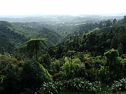
 Henderson Valley seen from the Waitākere Ranges | |
 | |
| Coordinates: 36°54′25″S 174°35′13″E / 36.907°S 174.587°E | |
| Country | New Zealand |
| Region | Auckland |
| Ward | Waitākere ward |
| Local board | Waitākere Ranges Local Board |
| Electorates | |
| Government | |
| • Territorial Authority | Auckland Council |
| Area | |
• Total | 15.04 km2 (5.81 sq mi) |
| Population (June 2024)[2] | |
• Total | 1,440 |
| • Density | 96/km2 (250/sq mi) |

Henderson Valley is a locality in West Auckland, New Zealand. The major road in the locality is Henderson Valley Road, and Scenic Drive is on the western boundary.[3]
- ^ Cite error: The named reference
Areawas invoked but never defined (see the help page). - ^ "Aotearoa Data Explorer". Statistics New Zealand. Retrieved 26 October 2024.
- ^ Topo50 map BA31 - Waitemata Harbour (Map). 1:50,000. Land Information New Zealand. 2016.