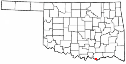
Hendrix, Oklahoma | |
|---|---|
 Location of Hendrix, Oklahoma | |
| Coordinates: 33°46′31″N 96°24′26″W / 33.77528°N 96.40722°W | |
| Country | United States |
| State | Oklahoma |
| County | Bryan |
| Area | |
| • Total | 0.12 sq mi (0.31 km2) |
| • Land | 0.12 sq mi (0.31 km2) |
| • Water | 0.00 sq mi (0.00 km2) |
| Elevation | 587 ft (179 m) |
| Population (2020) | |
| • Total | 61 |
| • Density | 512.61/sq mi (198.42/km2) |
| Time zone | UTC-6 (Central (CST)) |
| • Summer (DST) | UTC-5 (CDT) |
| ZIP code | 74741 |
| Area code | 580 |
| FIPS code | 40-33600[3] |
| GNIS feature ID | 2412744[2] |
Hendrix is a town in Bryan County, Oklahoma, United States. The population was 79 at both the 2010 and the 2000 censuses.[4] According to the Bryan County Genealogy Society, Hendrix was originally known as Kemp City. This led to it often being confused with the neighboring town that is simply named Kemp. Hendrix was largely destroyed by a 1916 tornado.
- ^ "ArcGIS REST Services Directory". United States Census Bureau. Retrieved September 20, 2022.
- ^ a b U.S. Geological Survey Geographic Names Information System: Hendrix, Oklahoma
- ^ "U.S. Census website". United States Census Bureau. Retrieved January 31, 2008.
- ^ CensusViewer:Hendrix, Oklahoma Population