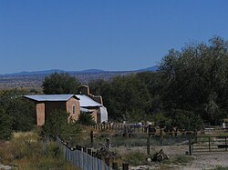
Hernandez | |
|---|---|
Unincorporated community and CDP | |
 | |
| Coordinates: 36°03′26″N 106°07′30″W / 36.05722°N 106.12500°W | |
| Country | |
| State | New Mexico |
| County | Rio Arriba |
| Area | |
| • Total | 1.7 sq mi (4 km2) |
| Elevation | 5,719 ft (1,743 m) |
| Population (2010) | |
| • Total | 946 |
| Time zone | UTC-7 (Mountain (MST)) |
| • Summer (DST) | UTC-6 (MDT) |
| ZIP code | 87537 |
| GNIS feature ID | 2584109[1] |
Hernandez is an unincorporated community and census-designated place in Rio Arriba County, New Mexico, United States. Hernandez is approximately 5 miles (8.0 km) northwest of Española on highway US 84 / US 285.
