Hespeler | |
|---|---|
Neighbourhood/ Dissolved town | |
 | |
| Nickname: The Beehive[1] | |
| Coordinates: 43°25′59″N 80°18′26″W / 43.4331°N 80.3072°W | |
| Country | Canada |
| Province | Ontario |
| Regional municipality | Waterloo |
| City | Cambridge |
| Settled | 1830 |
| Incorporated | 1901 |
| Amalgamated | 1973 |
| Time zone | UTC-5 (EST) |
| • Summer (DST) | UTC-4 (EDT) |
| Forward sortation area | |
| Area code(s) | 519 and 226 |
| NTS Map | 040P08 |
| GNBC Code | FCKDQ |
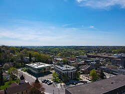
Hespeler is a neighbourhood and former town within Cambridge, Ontario, located along the Speed River in the Regional Municipality of Waterloo, Ontario, Canada.[2] In 1973, Hespeler, Preston, Galt, and the hamlet of Blair were amalgamated to form the City of Cambridge.[3] The first mayor of Cambridge was Claudette Millar.
No population data is available for the former Hespeler since the census reports cover only the full area of Cambridge. However, the combined population of the census tracts that cover what is now Hespeler was 26,391 as of the 2016 Canada Census.[4]
The neighbourhood of Hespeler is located in the most northeasterly section of Cambridge. Even in the early days it had an industrial base, primarily activity from woolen and textile mills.[5]
- ^ Cite error: The named reference
CambridgeGallery2was invoked but never defined (see the help page). - ^ "History, Cambridge Ontario". City of Cambridge. 2015. Retrieved 20 March 2017.
- ^ "Historical Information - Evolution of Hespeler". Archived from the original on March 30, 2013.
- ^ Population calculated by combining the populations of census tracts 0130.00, 0131.01, 0131.03, 0131.05 and 0131.06
- ^ "The History of Hespeler". City of Cambridge. 2015. Retrieved 22 March 2017.

