Hesperange
| |
|---|---|
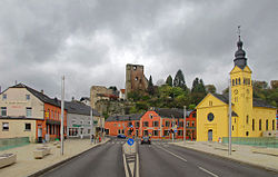
 View on Hesperange with its castle | |
 Map of Luxembourg with Hesperange highlighted in orange, and the canton in dark red | |
| Coordinates: 49°34′15″N 6°09′05″E / 49.5708°N 6.1514°E | |
| Country | |
| Canton | Luxembourg |
| Government | |
| • Mayor | Marc Lies (CSV) |
| Area | |
• Total | 27.22 km2 (10.51 sq mi) |
| • Rank | 32nd of 100 |
| Highest elevation | 334 m (1,096 ft) |
| • Rank | 90th of 100 |
| Lowest elevation | 255 m (837 ft) |
| • Rank | 58th of 100 |
| Population (2023) | |
• Total | 16,433 |
| • Rank | 7th of 100 |
| • Density | 600/km2 (1,600/sq mi) |
| • Rank | 14th of 100 |
| Time zone | UTC+1 (CET) |
| • Summer (DST) | UTC+2 (CEST) |
| LAU 2 | LU0000303 |
| Website | hesperange.lu |
Hesperange (French pronunciation: [ɛspəʁɑ̃ʒ]; Luxembourgish: Hesper [ˈhæspɐ] ; German: Hesperingen) is a commune and town in southern Luxembourg. It is located south-east of Luxembourg City.
The total population of the commune is 16,443 as of 2023, making it the seventh-most populous in the country.
As of 2024[update], the town of Hesperange, which lies in the centre of the commune, has a population of 2,914.[1] Other towns within the commune include Alzingen, Fentange, Howald, and Itzig. Each of these five towns has a population of over 1,000, making Hesperange unique amongst Luxembourgish communes in having five towns with over a thousand inhabitants (see: List of towns in Luxembourg by population).
Hesperange Castle, now a ruin, has a history dating from the 13th century.[2]
Hesperange has a park called Hesper Park which has a memorial commemorating the death of three American soldiers who died in a tank accident on the nearby bridge over the Alzette river on 26 December 1944 during the Battle of the Bulge.
- ^ "Registre national des personnes physiques RNPP : Population par localité". data.public.lu. 2024-01-07.
- ^ "Hesperange: History" Archived 2020-01-20 at the Wayback Machine, Association des châteaux luxembourgeois. Retrieved 3 April 2011.
