| High Bradfield | |
|---|---|
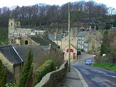
 High Bradfield village dominated by the Church of St. Nicholas, Bradfield | |
Location within Sheffield | |
| Civil parish |
|
| Metropolitan borough | |
| Metropolitan county | |
| Region | |
| Country | England |
| Sovereign state | United Kingdom |
| Post town | SHEFFIELD |
| Postcode district | S6 |
| Dialling code | 0114 |
| Police | South Yorkshire |
| Fire | South Yorkshire |
| Ambulance | Yorkshire |
| UK Parliament | |
High Bradfield is a rural village 6.5 miles (10 km) north-west of the centre of Sheffield in South Yorkshire, England and within the city's boundaries. The village lies just within the Peak District National Park, 1.3 miles (2 km) inside the park's north-eastern border, is at an altitude of 260 metres (850 feet) AOD, and has extensive views across Bradfield Dale towards Derwent Edge and the Dark Peak.
The most striking feature of the village is the medieval Church of St. Nicholas, Bradfield. It is one of only five Grade I Listed buildings in Sheffield.[1]
The name Bradfield failed to shift during the Great Vowel Shift from Old English to Broadfield, a name with a double emphasis on its broad stretch of open countryside.[2] and the area around the village is predominantly grazing land with dairy and sheep farming dominating. High Bradfield has a sister village, Low Bradfield, which lies less than 0.7 miles (1 km) to the south-west but is lower down in the upper Loxley valley. The two villages are linked by the steep Woodfall Lane.
High Bradfield is in the civil parish of Bradfield, the largest in England,[3] and in the electoral area of Stannington.
- ^ "Sheffield City Council website". Archived from the original on 21 August 2008. Retrieved 16 July 2015.
- ^ Local place names Bradfield and beyond. Gives translated meaning of name.
- ^ "Bradfield - Village - Visit Peak District". www.visitpeakdistrict.com. Retrieved 9 September 2018.
