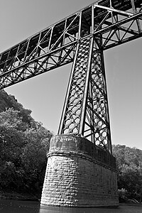
High Bridge, Kentucky | |
|---|---|
 High Bridge, 2008 | |
| Coordinates: 37°49′47″N 84°42′35″W / 37.82972°N 84.70972°W | |
| Country | United States |
| State | Kentucky |
| County | Jessamine |
| Area | |
| • Total | 2.33 sq mi (6.03 km2) |
| • Land | 2.18 sq mi (5.65 km2) |
| • Water | 0.15 sq mi (0.38 km2) |
| Elevation | 863 ft (263 m) |
| Population (2020) | |
| • Total | 268 |
| • Density | 122.94/sq mi (47.47/km2) |
| Time zone | UTC-5 (Eastern (EST)) |
| • Summer (DST) | UTC-4 (EDT) |
| Area code | 859 |
| FIPS code | 21-36460 |
| GNIS feature ID | 2629630[2] |

High Bridge is an unincorporated community and census-designated place in Jessamine County, Kentucky, United States. As of the 2010 census it had a population of 242.[3] It lies along the lower reaches of the Kentucky River across from the confluence of the Dix River with the Kentucky. The community is part of the Lexington–Fayette Metropolitan Statistical Area.
- ^ "2020 U.S. Gazetteer Files". United States Census Bureau. Retrieved March 18, 2022.
- ^ a b U.S. Geological Survey Geographic Names Information System: High Bridge, Kentucky
- ^ "Geographic Identifiers: 2010 Census Summary File 1 (G001): High Bridge CDP, Kentucky". American Factfinder. U.S. Census Bureau. Archived from the original on February 13, 2020. Retrieved June 25, 2018.

