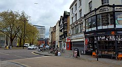
 High Street, Bristol, looking from the central crossroads towards Bristol Bridge. | |
| Maintained by | Bristol City Council |
|---|---|
| Location | Bristol, England |
| Postal code | BS1 |
| Coordinates | 51°27′16″N 2°35′33″W / 51.4545°N 2.5925°W |
| North | Broad Street |
| East | Wine Street |
| South | Bristol Bridge |
| West | Corn Street |
High Street, together with Wine Street, Broad Street and Corn Street, is one of the four cross streets which met at the carfax, later the site of the Bristol High Cross, the heart of Bristol, England when it was a walled medieval town. From this crossroads High Street runs downhill south-east to Bristol Bridge, a distance of approximately 155m.[1]
Once an important shopping street, wartime destruction and post-war planning have left High Street shabby and a constraint on pedestrian movement between the Old City and Castle Park. Bristol City Council are now seeking to redevelop the area to repair this.[2]
- ^ Watts, Lorna; Rahtz, Philip (1985). Mary-le-Port Bristol Excavations 1962/3. City of Bristol Museums and Art Gallery. pp. 16–17. ISBN 0-900199-26-1.
- ^ "The City Centre Framework - Old City - character statement and place plan" (PDF). Bristol City Council City Design Group. 2018. pp. 4–6. Archived (PDF) from the original on 28 May 2018. Retrieved 10 May 2018.
