| Higham | |
|---|---|
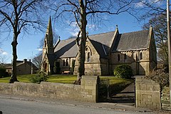
 Saint John the Evangelist Church | |
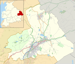
Location within Lancashire | |
| Population | 778 [1] |
| OS grid reference | SD805365 |
| Civil parish |
|
| District | |
| Shire county | |
| Region | |
| Country | England |
| Sovereign state | United Kingdom |
| Post town | BURNLEY |
| Postcode district | BB12 |
| Dialling code | 01282 |
| Police | Lancashire |
| Fire | Lancashire |
| Ambulance | North West |
| UK Parliament | |

Higham is a village in the Borough of Pendle in Lancashire, England, south of Pendle Hill. The civil parish is named Higham with West Close Booth. The village is 2 miles (3 km) north-east of Padiham and about 4 miles (6 km) south-west of Nelson along the A6068 road.
According to the United Kingdom Census 2011, the parish has a population of 778,[1] a decrease from 808 in the 2001 census.[2]
The parish adjoins the other Pendle parishes of Goldshaw Booth, Old Laund Booth and Reedley Hallows, the Burnley parishes of Ightenhill and Padiham, and the Ribble Valley parishes of Simonstone and Sabden. The area of the parish north of Stump Hall Road is part of the Forest of Bowland Area of Outstanding Natural Beauty (AONB).[3]
- ^ a b UK Census (2011). "Local Area Report – Higham-with-West Close Booth Parish (1170215072)". Nomis. Office for National Statistics. Retrieved 3 March 2018.
- ^ Office for National Statistics : Census 2001 : Key Statistics[permanent dead link] Retrieved 2 September 2015
- ^ Forest of Bowland map (Map). forestofbowland.com. Lancashire County Council.

