| Hill River South Australia | |||||||||||||||
|---|---|---|---|---|---|---|---|---|---|---|---|---|---|---|---|
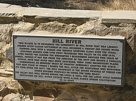
 HILL RIVER plaque at junction of Weckerts Road and Clare-Farrell Flat Road, South Australia | |||||||||||||||
| Coordinates | 33°48′21″S 138°41′14″E / 33.805730°S 138.687090°E | ||||||||||||||
| Population | 98 (SAL 2021)[1] | ||||||||||||||
| Established | 2001[2] | ||||||||||||||
| Postcode(s) | 5453[3][2] | ||||||||||||||
| Time zone | ACST (UTC+9:30) | ||||||||||||||
| • Summer (DST) | ACST (UTC+10:30) | ||||||||||||||
| Location | 127 km (79 mi) N of Adelaide city centre[3] | ||||||||||||||
| LGA(s) | Clare and Gilbert Valleys[2] | ||||||||||||||
| Region | Yorke and Mid North[4] | ||||||||||||||
| State electorate(s) | Frome[5] | ||||||||||||||
| Federal division(s) | Grey | ||||||||||||||
| |||||||||||||||
| |||||||||||||||
| Footnotes | Coordinates[2] Climate[7] | ||||||||||||||
Hill River is a locality in the Yorke and Mid North region of South Australia, about 127 kilometres (79 miles) north of the Adelaide city centre. It is bisected by the Hill River, an ephemeral stream from which it derives its name.[3][4] Its boundaries were created in January 2001 for the “long established name.”[2]
Hill River is located within the federal division of Grey, the state electoral district of Frome and the local government area of the District Council of Clare and Gilbert Valleys.[6][8][5]
- ^ Australian Bureau of Statistics (28 June 2022). "Hill River (SA) (suburb and locality)". Australian Census 2021 QuickStats. Retrieved 28 June 2022.
- ^ a b c d e f g h i j k l m n o p "Search result for "Hill River (Locality Bounded)" (Record no SA0031738)". Department of Planning, Transport and Infrastructure. Archived from the original on 12 October 2016. Retrieved 12 November 2015.
- ^ a b c "Hill River SA Postcode". Australian Postcode Finder. Retrieved 12 November 2015.
- ^ a b "Yorke and Mid North SA Government region" (PDF). The Government of South Australia. Retrieved 10 October 2014.
- ^ a b "Frome electorate boundaries as of 2014". ELECTORAL COMMISSION SA. Retrieved 12 November 2015.
- ^ a b c d e "Map". Clare & Gilbert Valleys Council. Retrieved 12 November 2015.
- ^ "Summary statistics CLARE HIGH SCHOOL". Bureau of Meteorology, Commonwealth of Australia. Retrieved 3 February 2016.
- ^ "Federal electoral division of Wakefield" (PDF). Australian Electoral Commission. Retrieved 12 November 2015.
